Tropical Storm Ophelia Updates
UPDATE 9/23, 4:00 PM
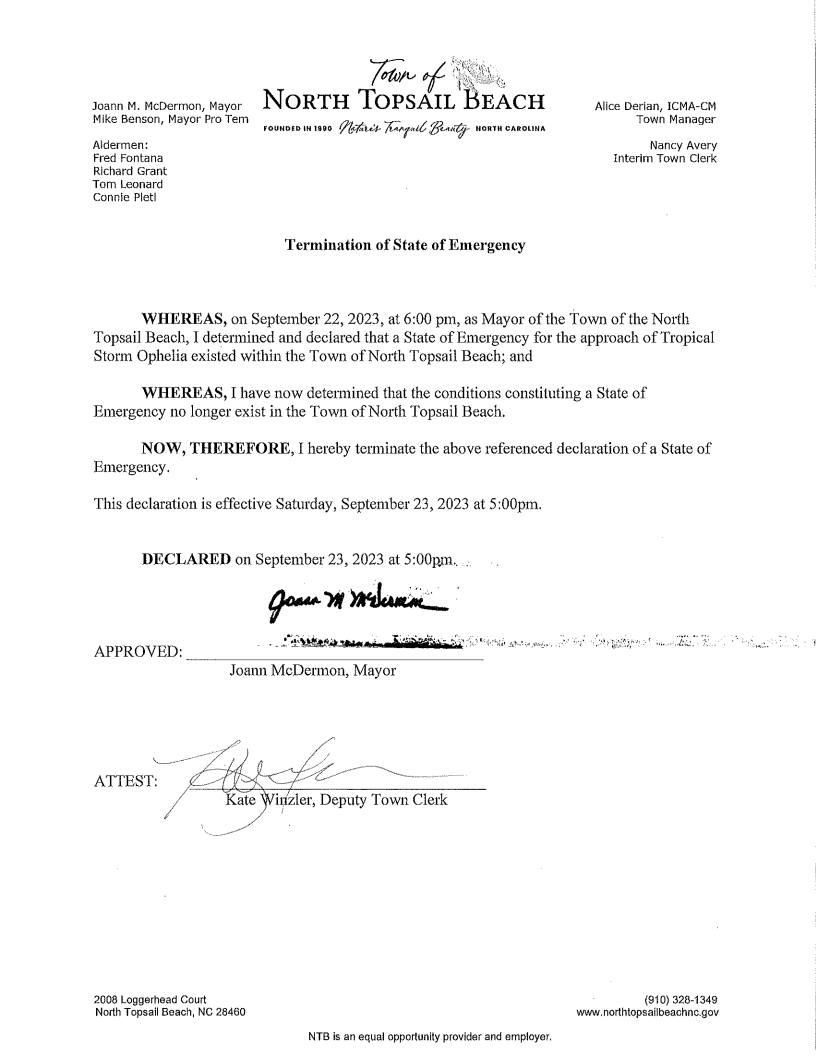
On September 22, 2023 at 6:00 pm, the Mayor declared a State of Emergency for the approach of Tropical Storm Ophelia. It is determined that the conditions constituting a State of Emergency no longer exist and hereby terminate the declaration of a State of Emergency effective September 23, 2023 at 5:00pm. Please continue to be mindful of DANGEROUS Rip Currents throughout this weekend and some standing water as it recedes particularly on Island Drive near Gray Street.
UPDATE 9/22, 7:30 PM
Please be advised that the Town of North Topsail Beach has declared a State of Emergency as a result of the approach of Tropical Storm Ophelia. The Governor of the State of North Carolina has declared a state of emergency effective today and therefore the Mayor of North Topsail Beach has deemed it necessary to declare a state of emergency for today effective at 6:00pm with no restrictions. Town staff continue to monitor this event. We encourage all residents to do the same. Be safe and stay informed.
UPDATE 9/22, 3:00 PM
Potential Tropical Cyclone Sixteen has gained tropical characteristics and is now Tropical Storm Ophelia. North Topsail Beach remains under a Tropical Storm Warning. Impacts will continue through Saturday. Anticipated impacts are rainfall of 3 to 4 inches, 1 to 4 ft storm surge and tropical storm force winds and near hurricane force gusts are possible. Be mindful of the next scheduled high tides on Saturday at 1:34am and 2:25pm. North Topsail Beach will continue to provide information and updates on the Town’s website and Facebook page. Dangerous Rip Currents are expected through the weekend. Stay informed and be safe.
UPDATE 9/22, 10:00 AM
Tropical Storm Warning Operations Update for today:
Town staff began yesterday and is finishing up today tying down loose items and cans at our access points. We encourage you to prepare and do the same. We had a call with our trash/recycling service provider this morning and they anticipate being able to provide pick-up service tomorrow as scheduled. Pick-ups will start around 7am and expected to be completed by 3pm. Should any changes in the schedule occur, we have asked the contractor to provide an update so we can let you know.
Staff will be deploying the road closed signs later this morning at New River Inlet Road in front of the Reef at the intersection advising of high water and road closure. This is to plan in advance of the high tide this afternoon at 1:17pm and will remain up for the duration of this weather event. The roadway will remain open for residents and emergency personnel but ask all others to refrain from driving through this area. The drive on access is also being closed at the same time today and will remain closed until further notice. We anticipate being able to re-open on Sunday.
The asphalt repairs to the roadway near the Drive on area that was scheduled for this week has been postponed to Monday morning. We anticipate this work to begin Monday morning and be completed by end of day on Tuesday. Signage will be deployed to this area and the parking lot and drive on area will be closed while work is being done.
Staff continues to monitor the storm and will continue to provide updates throughout the event. Be informed from reliable sources, have a plan, and stay safe!
UPDATE:
The National Weather Service has issued a Tropical Storm Warning for our area. The Town will continue to monitor the storm and post updates as they become available. We expect to see some impacts beginning Friday morning that will continue through Saturday. Anticipated impacts for NTB include rainfall of 3 inches to 4 inches , 1-to-4-foot storm surge and potential wind gusts of 39-57 mph. Please be mindful of high tides on Friday at 12:30am and 1:17pm and on Saturday at 1:34am and 2:25pm.
Please secure all loose items or bring inside. If you have not already signed up for CodeRed notifications, please consider doing so at this time. https://public.coderedweb.com/CNE/en-US/BF72715B868F
An area of low pressure is forecast to develop off the Southeast coast late this week, which will lift across or just offshore of the Carolinas this weekend. There is still a lot of uncertainty with the strength and track of this system, as well as the potential impacts, but we are most confident that much of the area will see significant rainfall.
In addition, long period swells from Hurricane Nigel in the Central Atlantic will begin to impact the beaches later this week bringing large surf and an increased rip current threat.