High Rip Current Risk
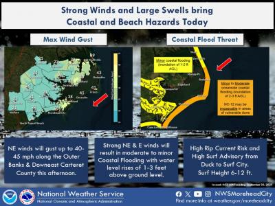
9/30/25 @ 530 am: Tight pressure gradients between TS Imelda and Hurricane Humberto offshore and high pressure building in from the north will bring strong NE winds across the region today. This will result in several coastal and marine hazards across the region today, including:
- Coastal Flood Warning and Advisories for the potential for 1-3 ft of inundation, including the possibility of overwash along vulnerable locations along Hatteras and Ocracoke Islands.
- High Rip Current Risk and a High Surf Advisory along ENC Beaches.
- Gale Warnings across most of the waters.
- Wind Advisory for Hatteras and Ocracoke Islands and Down East Carteret Co.


